ANALYSIS & FINDINGS

The AST Master Plan asks:
- How busy will the Airport be in 20 years?
- What are the future trends and challenges in aviation?
- Does the airport have the facilities it will need in the future?
- What are the vehicle access and parking needs?
- What are the highest and best uses for airport property?
- What are opportunities to generate revenue for the airport?
- What are the economic development and land use opportunities?
Click the links below to review a specific section:
Facility Needs
|
Environment
|
Alternative Development
|
Parking & Circulation
|
Compatibility
|
Financial Feasibility
FACILITY NEEDS
-
Airfield
- Limit runway crossings to the outer thirds of the runway to comply with FAA guidance.
- Relocate Taxiway A to the south by 30 feet to allow visibility minimums at Runway End 26.
-
Aircraft Storage
- Identify future hangar development locations in order to increase the capacity at the Airport and meet the needs of future demand.
- Anticipate additional parking needs for civilian and USGC helicopters, as based helicopters are projected to increase.
-
Non-Aeronautical
- Evaluate non-aeronautical development opportunities

ENVIRONMENT
ENVIRONMENT
-
Overview
- Assist in the avoidance and minimization of environmental effects
- Environmental resources known to occur on or near AST:
- Coastal Zone
- Cattle Grazing (agricultural use)
- Federally listed threatened or endangered species
- Fish in the Vera Slough and Columbia River
- Floodplains
- Wetlands
-
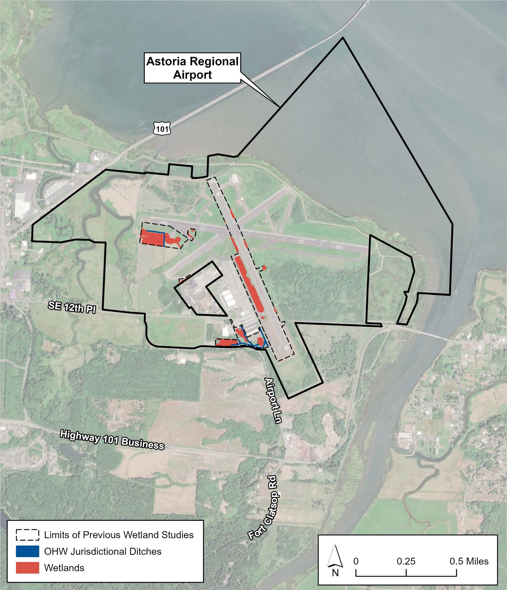
Wetlands
Available resource documents as well as site-specific studies indicate that much of the Airport, including areas underlain by fill, are occupied by jurisdictional wetland. Any improvements that disturb previously unpaved areas will require a wetland delineation study and will likely require wetland mitigation.

PARKING & CIRCULATION
-
Wayfinding Signage
- Limited signage to FBO
- New signage along SE 12th Pl and Flight Line Dr
- New signage to businesses could improve visitor experience
-
General Public Access
SE 12th Place
- Airport access
- Adequate capacity
Flight Line Drive:
- Access to FBO and Employee /Public Parking
- Adequate capacity
- Circulation at FBO could be improved with delineated parking/circulation
-
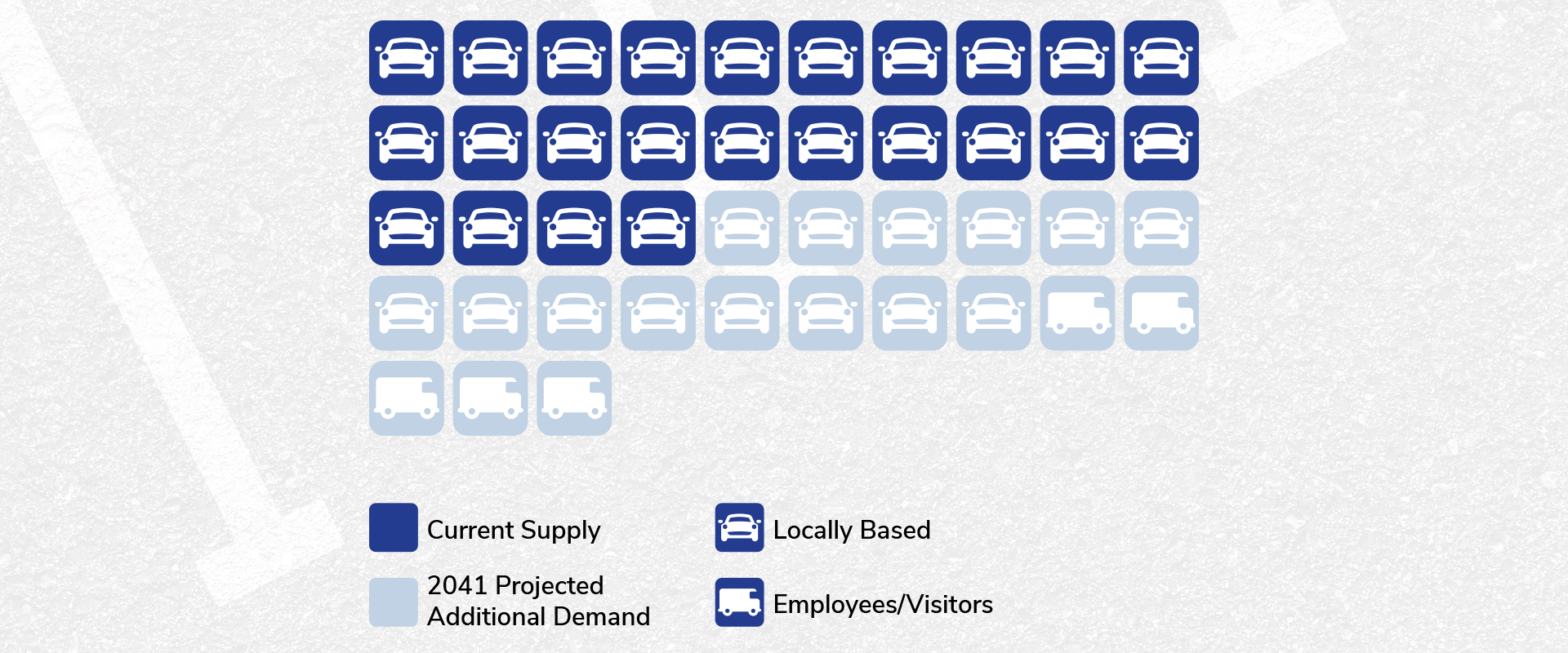
Current Parking Conditions
Parking Supply
- 24 spaces at the terminal building
- Paved and unpaved surface parking
- Additional parking designated for leased tenants
Primary Access
- SE 12th Place and SE Airport Lane
COMPATIBILITY
-
Airspace
What are Part 77 Surfaces?
Part 77 is a federal regulation that establishes standards and notification requirements for objects affecting navigable airspace. It allows the FAA to identify potential aeronautical hazards in advance.
The Part 77 surfaces are imaginary surfaces that size is based on the category of each runway according to the type of approach available or planned for that specifc runway.
-
Noise
Airport noise contours are a graphical representation of projected noise exposure levels associated with aircraft operations in areas adjacent to the airport.
Noise contours identify areas around the airport exposed to aircraft noise which may impact long term amenity of these areas. Noise is measured using 'contours'; these map the noise energy over a period.
-
Traffic Pattern
Airport traffic patterns are standardized paths for coordinating traffic. They are developed to ensure that air traffic is flown into and out of the airport safety.
These traffic patterns are established based on local conditions, including direction and placement of the pattern, altitude being flown and procedures for entering and exiting the pattern.
FINANCIAL FEASIBILITY
-
Funding Participation
National Plan of Integrated Airports (NPIAS)
- Astoria is designated as a General Aviation, Local airport
- Grant covers 90-95% of eligible costs
-
Airport Improvement Program (AIP)
Eligible projects include those improvements related to enhancing airport safety, capacity, security, and environmental concerns:
- Runway/Taxiway/Apron for construction/rehabilitation
- Airfeld lighting, signage, drainage
- AWOS, NAVAIDS, REILs & PAPIs
- Land acquisition
- Planning studies
-
Funding Sources
Federal Funding
FAA Airport Improvement Program (AIP)
- Entitlements
- Discretionary
State Funding
- Oregon Grants
Local Match
- About 10% of costs would be covered by local airport funds
Airport Funds
- Airport Revenue
Airport Bonds
All Rights Reserved | Port of Astoria